Bay Park Data Solutions (Bay Park) is proud to be recognized as the FIRST to receive the new Nonprofit Specialty designation from Esri. Esri is the global leader in GIS software and location intelligence. This new specialty designation, which was announced on June 22, 2021, is only open to Esri Partner Network Organizations who would like to be identified as specialists in the Nonprofit sector.
On July 29th, after a rigorous application process, Bay Park Data Solutions was the first to earn this Specialty Designation.
Partners in the Nonprofit Specialty are recognized for their alignment with Esri’s Nonprofit Partner Specialization (Esri)
As a partner in the Nonprofit Specialty, Bay Park Data Solutions is recognized for their expertise and for delivering services and developing solutions leveraging Nonprofit environments.
Since Bay Park was founded, they have focused on helping Nonprofit organizations collect, monitor and evaluate their domestic and international development projects. Their vision has been to empower nonprofits by providing services that generate comprehensive and geographically targeted insights to help them better communicate their value to their donors and stakeholders and ultimately create a better world.
“We couldn’t be happier to be the very first Esri Partner Network organization to receive this Nonprofit Specialty Designation! We are excited to learn about other partners in the space and how we can all work together to help Nonprofits achieve their goals.” – Martha Rodgers, Founder, Bay Park Data Solutions
A few success stories from Bay Park’s Nonprofit work:
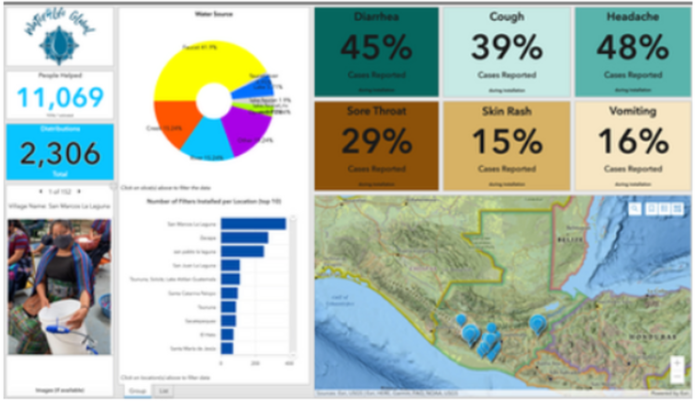
Developed a mobile survey using ArcGIS Survey123 to help Water4Life Global increase Monitoring and Evaluation (M&E) efforts in Guatemala to demonstrate impact and outcomes and improve transparency for their water filter distribution efforts. (https://water4lifeglobal.org/). See image below
Developed a native mobile application for members of the Global CHE Network to help them access Lesson Plans and share their individual success stories with other members. (https://www.chenetwork.org/)
Developed a 3D public facing web application to collect information about Peace Poles planted around the World. (https://www.worldpeace.org/)
Developed a process to integrate data between Google Sheets, ArcGIS, Classy & Salesforce.
Developed a process to automate quality control of data and send email acknowledgements.


