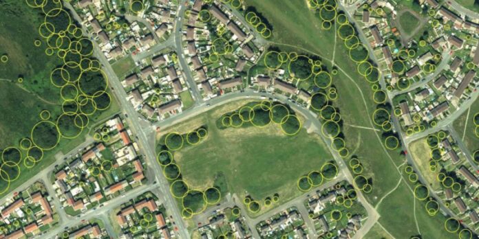
Bluesky International’s geospatial data is providing environmental insights and informing future green space plans in a bid to enhance resident well-being, improve air quality, maximise biodiversity and improve surface water management at a large housing estate on the outskirts of Swansea, Wales.
The Green Infrastructure Consultancy, is a UK based company advising private, government, institutional and NGO clients on urban green infrastructure policy, strategy, planning, design, installation and maintenance. It is working with the housing association Pobl on mapping green infrastructure and opportunities for improvement around the Penderi housing estate.
The consultancy has been tapping into Bluesky’s National Tree Map (NTM) which provides accurate height, location and canopy coverage data for trees 3m and taller. For the Penderi project, The Green Infrastructure Consultancy has interrogated additional datasets that look at existing habitats and species, topography, vegetation cover, flood risk, accessibility to greenspace and ecosystem resilience.
Gary Grant of The Green Infrastructure Consultancy said: “Pobl understands how important high quality and accessible green infrastructure is for residents health and wellbeing and how green infrastructure will be at the forefront of their efforts to mitigate for, and adapt to, climate change. They have a sophisticated approach that requires access to data and good maps.”
“As a business we advise on the various ways to bring green infrastructure to urban areas and in the example of Penderi, we have used Bluesky’s NTM to assess the existing green canopy cover and how this can be expanded on, ensuring the data guides us as to the right locations for new tree plantings.”
Ralph Coleman, Sales Director at Bluesky, added: “Planting trees in the right locations can have numerous environmental benefits like ground water absorption to reduce the likelihood of flash flooding, improving air quality and providing cooling for surrounding buildings. The UK has significant tree planting targets to hit over the next 2/3 years. In 2021 the Government committed to increasing tree planting across the UK to 30,000 hectares per year. However, using accurate, up to date data will be key in ensuring time and resource are maximised and trees are planted in areas where they will thrive without damaging other environmental habitats.”
The National Tree Map includes data for all trees 3m and taller in Great Britain and Ireland. It is a unique dataset that was created by Bluesky and is updated on a three-year rolling flying programme. Further details can be found at: National Tree Map | Bluesky International Limited (bluesky-world.com)
About Bluesky and the National Tree Map
Bluesky’s National Tree Map is created using innovative algorithms and image processing techniques in combination with the most up to date and detailed aerial photography. In addition to the three vector map layers; Crown Polygons, Idealised Crowns and Height Points, the Bluesky National Tree Map also includes an attribute table including unique identification for each crown feature, height attributes and area calculations. The data is available in a range of formats for use in GIS, CAD and online mapping tools and is currently available for the whole of England, Wales, Scotland and the Republic of Ireland.
Bluesky International is the leading aerial survey and geographic data company in the UK producing and maintaining seamless digital aerial photography and height data on a national scale in both Great Britain and the Republic of Ireland. Bluesky also undertakes bespoke surveys, including LiDAR, for a range of public and private sector clients.
Bluesky International operates a range of aircraft and sensors including three Ultracam Eagle Mark 3s, two CityMappers which allow the simultaneous collection of vertical and oblique imagery, as well as LiDAR data, and a Galaxy LiDAR which is mounted with a thermal sensor and survey grade camera. These systems put Bluesky International in the enviable position of being able to provide customers with unique and cost-effective geospatial solutions.
As well as being an established and respected aerial survey company Bluesky International is also highly innovative and continually strives to develop new products and services by embracing new technology and methods. This has resulted in the development of some unique products such as the National Tree Map (NTM).
These datasets underpin long term contracts with local and central governments and many major blue-chip companies from a range of market sectors including financial services, utilities, telecoms, web portals, construction and environment. Bluesky International has offices in the UK, US, Republic of Ireland and a dedicated production centre in India.


