


Technology has made a significant impact in the surveying world. Geographic information systems (GIS) are a sophisticated form of mapping software that enables users to visually display input data associated with a designated project. GIS helps users create interactive smart maps that visualize spatial information and help make better and wiser business decisions that are important for the organization of work. GIS benefits organizations of all sizes and in almost every industry. In fact, there is a growing interest of the economic and strategic value of GIS of more standards-based technology and a greater awareness of the benefits demonstrated by the GIS users. Sometimes you can’t read your data and visualize it at the same time. GIS is the right solution to help you achieve that ultimate goal, and communicate something raw data isn’t able to do.
“GIS is critical to the functioning of almost every aspect of society, from governments to private companies to NGOs. It allows one to see and plan and manage anything in its real-world spatial context,” says Gavin Fleming, Joint MD at Kartoza.
On the other hand, according to Geomaps Africa Executive Chairman, Hon. Lenny Kivuti, With Geographic Information System (GIS) as one of the information systems, there is increasing demand for geospatial information and tools, which has brought GIS into the daily lives of people. GIS is critical to various organizations and businesses today and the use of geospatial technology tools is widening due to their capability to improve development and planning of nations. Various GIS applications have been providing the frameworks and processes for enabling achievement of sustainable development goals across the world. With over 36 years of experience in GIS industry, Geomaps Africa has proven the value of geospatial data in achieving growth and digital transformation.
 “Digital data information has today turned out to be the basis on which national governments, county governments, industries and organizations make their decisions. They use geospatial data in a wide variety of areas, including legislative and policy development, allocation and management of natural resources, defense and public safety purposes and spatial planning among others,” says Hon. Kivuti. “In Geomaps Africa ,we prioritized geospatial data as a critical asset for decision making, the reason we have strategically invested in the state-of-the-art equipment, tools and methodologies that are used to collect, manage and analyze the most accurate geospatial data,” he adds.
The future of GIS mapping in Africa
With the ability to make maps that communicate, perform analysis, share information, and solve complex spatial problems, GIS has made our lives easier and can significantly reduce operational and administrative costs.
“It’s a growth industry, like it is in the rest of the world. African countries could reduce the expense of GIS implementation and reduce their dependency on foreign aid by adopting FOSS GIS, building local FOSS GIS skills and local FOSS GIS solutions, which will all benefit their local economies,” asserts Fleming.
 Conferring with Hon. Kivuti, he is certain that, the future of GIS mapping is promising due to the demand for geospatial data for development and national planning. Currently, many African organizations are investing millions of dollars on GIS technology to ensure it lives to expectations in order to serve the need of the people around. This is evident by growing rate of African geospatial companies e.g. Geomaps Africa since establishment. Geomaps Africa founder, Hon. Lenny Kivuti started Geomaps Africa 37 years ago, with a single idea that Africa was ready for Geospatial services paralleling the first world, and observing that the continent was being left behind as new Geospatial technology was breaking out. Since then, Geomaps has grown to a major player in geospatial technology and today, it’s a large multinational consultancy spanning across Africa and beyond.
“On the other hand, geospatial professional have drastically increased in Africa and today, there are many Universities across Africa who are teaching and training students on various geospatial disciplines. These and many more example in African countries are evident that the future of GIS in Africa has no limit,” Says Hon. Kivuti.
Geographic Information Systems (GIS) was developed by Dr. Roger Tomlinson in 1960 in Ottawa by the Canadian Department of Forestry and Rural Development. it was called the Canada Geographic Information System (CGIS) and was used to store, analyze, and manipulate data collected for the Canada Land Inventory, an effort to determine the land capability for rural Canada by mapping information about soils, agriculture, recreation, wildlife, waterfowl, forestry and land use.
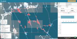
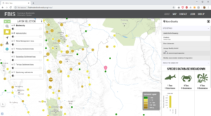
Today, GIS has revolutionized our ability to communicate the full scope of our work accurately, openly, comprehensively and in compelling visual manner. Entrenched in the science of geography, GIS analyses spatial location and organizes layers of information into visualizations using maps and 3D scenes. With no doubt GIS is a powerful tool that can be successfully implemented to help address a number of significant decision-making processes.
