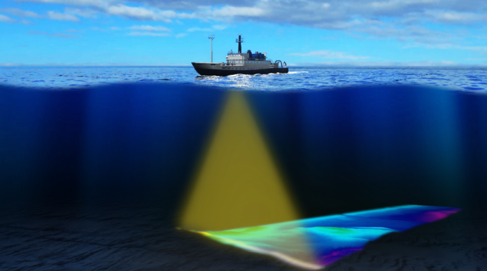
Seabed mapping is crucial for a multitude of applications, from navigation and resource exploration to environmental monitoring. Multibeam sonar technology has transformed seabed mapping by providing exceptional benefits in efficiency, precision and data quality. This cutting-edge technology uses multiple sonar beams at once, enabling marine researchers and surveyors to obtain highly detailed images of the seafloor with exceptional accuracy.

Brian Connon, Saildrone VP Ocean Mapping and President of The Hydrographic Society of America states that, “Multibeam mapping of the seabed provides many benefits to multiple end users from ship captains and port authorities to marine biologists and climate scientists and even government and commercial economic entities.”
This is how multibeam technology revolutionizes the underwater surveying:
I. Improved Accuracy and Precision
The multiple beams and advanced processing techniques inherent in multibeam sonar systems contribute to improved accuracy and precision in seabed mapping. Multiple measurements of the same area help to reduce errors caused by factors such as sound wave refraction and scattering.
This accuracy is critical for applications such as navigational charting, where precise depth information is essential for safe vessel operation and for engineering projects where accurate topographic knowledge is vital for successful design and construction.
Emphasizing on accuracy and precision, Connon states that, “Detailed information on underwater topography is essential for safe navigation, proactive coastal management, and improving our understanding of weather and climate”
He explains further, “Updated nautical charts from multibeam mapping provide safer transit of marine shipping and can increase port traffic due to greater confidence in the quality of those charts. Coastal areas benefit from improved numerical modeling of sea level rise, waves and currents, and tsunami and storm surge forecasting, which enables improved coastal resilience.”
II. Efficiency and Data Acquisition Rate
Multibeam systems simultaneously transmit multiple beams across a swath of the seabed. This enables a rapid acquisition of vast amounts of bathymetric data, significantly reducing survey time and operational costs.
III. High-Resolution Data
The high resolution sanctions for the identification of even subtle features on the ocean floor, such as small-scale geological formations, wrecks, pipelines and biologically significant habitats. This kind of high resolution is crucial for applications requiring precise measurements, such as cable route planning or the identification of unexploded ordnance (UXO). The improved resolution facilitates the creation of more accurate digital elevation models (DEMs) with significantly enhanced positional accuracy compared to single-beam systems.
IV. Integration with Other Technologies
Multibeam sonar technology does not exist in isolation; its effectiveness is often amplified by its integration with other technologies.
For example, simultaneous use of multibeam sonar with sub-bottom profilers can provide information not only about the surface of the seabed but also about subsurface layers, revealing sediment structures and geological formations that lie beneath. Similarly, the integration of other sensors, such as side-scan sonar or optical cameras, can provide complementary data, contributing to a more holistic understanding of the underwater environment.
This integrated approach maximises the potential of seabed mapping, furnishing a far richer and more complete dataset than any single technology could achieve alone.
V. Versatility Across Applications
Multibeam sonar offers versatility in various applications. including offshore construction, dredging operations, environmental monitoring and underwater archaeology, among others.
According to Connon, “Important economic endeavors such as maritime transport, marine aquaculture, power and telecommunications cables, and offshore energy require this information for accurate navigation and safe placement of offshore infrastructure.”
Additionally, the versatility of multibeam sonar makes it a valuable tool across industries, enhancing the effectiveness of seabed mapping projects. Its high-resolution, accurate data enables engineers and scientists to make informed decisions about seabed suitability for infrastructure development, identify potential hazards in dredging operations, monitor environmental changes, and uncover hidden underwater treasures.
VI. Real-time Data Processing
Multibeam sonar systems are often equipped with real-time data processing capabilities, which offer several advantages for seabed mapping operations. Onboard processing allows operators to quickly assess the quality of acquired data and make timely adjustments to improve the overall data collection process.
This capability reduces the need for extensive post-processing and minimizes the risk of having to revisit a site for additional data collection, resulting in a more efficient seabed mapping exercise.
VII. Backscatter Capabilities
Backscatter data measures the intensity of the returning acoustic signal, providing information about the seafloor’s physical properties, such as roughness, composition, and sediment type. “Acoustic backscatter and water column mapping also provide key insights into benthic habitats, geologic features, and fish stocks. Multibeam mapping provides knowledge of a country’s underwater territory-an area that may hold unique and valuable resources. This information is a major component of developing a successful Blue Economy,” asserts Connon.
This additional information layer enhances the interpretative power of the data, enabling researchers and engineers to distinguish between different seabed materials, identify potential hazards, and characterize habitats with greater precision.
VIII. Safer Data Collection
Multibeam sonar proves beneficial particularly in challenging environments such as those with strong currents, turbid waters or complex seabed topography. The system’s ability to acquire data rapidly and efficiently, even under less-than-ideal conditions, minimizes the time spent in potentially hazardous areas, enhancing the overall safety of the survey operation. The identification of previously unknown obstacles, like sunken wrecks or sharp underwater cliffs, is crucial for preventing accidents and ensuring the safety of personnel and survey vessel.
The Seabed Floor at Clarity
The adoption of multibeam sonar represents a significant advancement in seabed mapping capabilities. This powerful technology provides a far more comprehensive and detailed picture of the ocean floor, leading to improved accuracy and efficiency in your mapping projects. As technology continues to improve, we can anticipate even finer resolution, faster data acquisition and broader applications across various disciplines. This will lead to a more comprehensive understanding of our oceans, facilitating better management of resources, protection of marine life and ensuring safer navigation.


